Bibra Lake night lights from space
Night Light of Bibra Lake (Western Australia) from space (Australia) Src. Average luminocity for 10x10km area is 84.1066% and for 50x50km: 38.4405%.
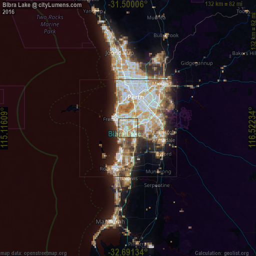
Analysis of Bibra Lake night lights 2016
Square area 10x10 km:
 19.06%
90-99
26.22%80-89
13.46%70-79
22.73%60-69
13.46%50-59
4.37%40-49
0.7%30-39
0%20-29
0%10-19
0%0-9
0%Square area 50x50 km:
8.58%90-99
9.01%80-89
4.22%70-79
5.33%60-69
7.8%50-59
5.14%40-49
3.47%30-39
3.29%20-29
5.69%10-19
8.22%0-9
39.25%Clear (daylight) street map image can be seen on geolist.org.
Map coordinates:
31° 30' 0.2" South, 115° 6' 57.9" East
32° 5' 51.5" South, 115° 49' 9.2" East
32° 41' 28.8" South, 116° 31' 20.4" East
Some cities around Bibra Lake sort by population:
• Leeming
5.1 km =3.2 mi,  60°
60°
• Hamilton Hill
4 km =2.5 mi,  291°
291°
• Spearwood
4 km =2.5 mi,  257°
257°
• Kardinya
3.6 km =2.2 mi,  353°
353°
• Yangebup
2.6 km =1.6 mi,  186°
186°
• Beeliar
4.2 km =2.6 mi,  196°
196°
• South Lake
2.4 km =1.5 mi,  129°
129°
• Coolbellup
2.2 km =1.4 mi,  325°
325°
8349024 (p: 5,744)
Sources (retrieved 2019-11-25):
» Earth at Night: Flat Maps 2012, 2016