Spearwood night lights from space
Night Light of Spearwood (Western Australia) from space (Australia) Src. Average luminocity for 10x10km area is 65.0892% and for 50x50km: 36.5394%.
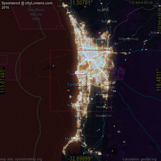
Analysis of Spearwood night lights 2016
Square area 10x10 km:
 11.36%
90-99
16.78%80-89
10.31%70-79
13.99%60-69
11.71%50-59
6.12%40-49
5.77%30-39
1.92%20-29
12.94%10-19
8.92%0-9
0.17%Square area 50x50 km:
8.29%90-99
8.72%80-89
4.2%70-79
5.24%60-69
7.31%50-59
4.69%40-49
3.36%30-39
2.82%20-29
5.19%10-19
6.29%0-9
43.89%Clear (daylight) street map image can be seen on geolist.org.
Map coordinates:
31° 30' 28.1" South, 115° 4' 29.5" East
32° 6' 19.2" South, 115° 46' 40.7" East
32° 41' 56.4" South, 116° 28' 52" East
Some cities around Spearwood sort by population:
• Hamilton Hill
2.3 km =1.4 mi,  3°
3°
• Fremantle
6.2 km =3.9 mi,  330°
330°
• Kardinya
5.6 km =3.5 mi,  38°
38°
• Yangebup
4 km =2.5 mi,  115°
115°
• Beeliar
4.1 km =2.5 mi,  139°
139°
• South Lake
5.8 km =3.6 mi,  96°
96°
• Bibra Lake
4 km =2.5 mi,  77°
77°
• Coolbellup
3.8 km =2.4 mi, 44°
2061224 (p: 9,872)
Sources (retrieved 2019-11-25):
» Earth at Night: Flat Maps 2012, 2016