South Lake night lights from space
Night Light of South Lake (Western Australia) from space (Australia) Src. Average luminocity for 10x10km area is 78.2028% and for 50x50km: 37.5801%.
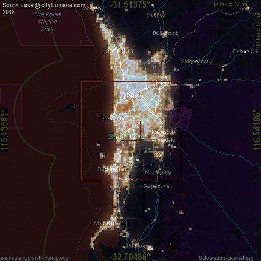
Analysis of South Lake night lights 2016
Square area 10x10 km:
 16.96%
90-99
20.98%80-89
9.79%70-79
20.45%60-69
15.03%50-59
7.69%40-49
4.9%30-39
3.32%20-29
0.87%10-19
0%0-9
0%Square area 50x50 km:
8.25%90-99
8.6%80-89
4.13%70-79
5.24%60-69
7.62%50-59
5.11%40-49
3.49%30-39
3.34%20-29
5.72%10-19
8.37%0-9
40.13%Clear (daylight) street map image can be seen on geolist.org.
Map coordinates:
31° 30' 49.5" South, 115° 8' 8.2" East
32° 6' 40.5" South, 115° 50' 19.4" East
32° 42' 17.5" South, 116° 32' 30.7" East
Some cities around South Lake sort by population:
• Leeming
4.8 km =3 mi,  32°
32°
• Success
3.7 km =2.3 mi,  163°
163°
• Atwell
4.4 km =2.7 mi,  145°
145°
• Kardinya
5.6 km =3.5 mi,  336°
336°
• Yangebup
2.4 km =1.5 mi,  243°
243°
• Beeliar
3.9 km =2.4 mi,  231°
231°
• Bibra Lake
2.4 km =1.5 mi,  309°
309°
• Coolbellup
4.5 km =2.8 mi,  317°
317°
10057011 (p: 5,774)
Sources (retrieved 2019-11-25):
» Earth at Night: Flat Maps 2012, 2016