Coolbellup night lights from space
Night Light of Coolbellup (Western Australia) from space (Australia) Src. Average luminocity for 10x10km area is 86.8829% and for 50x50km: 39.5099%.
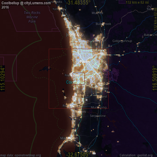
Analysis of Coolbellup night lights 2016
Square area 10x10 km:
 24.3%
24.3%90-99
29.02%80-89
13.64%70-79
22.38%60-69
6.12%50-59
3.15%40-49
1.4%30-39
0%20-29
0%10-19
0%0-9
0%Square area 50x50 km:
9.07%90-99
9.57%80-89
4.27%70-79
5.42%60-69
8.04%50-59
5.14%40-49
3.44%30-39
3.14%20-29
5.55%10-19
7.59%0-9
38.78%Clear (daylight) street map image can be seen on geolist.org.
Map coordinates:
31° 29' 0.8" South, 115° 6' 10.6" East
32° 4' 52.5" South, 115° 48' 21.8" East
32° 40' 30.2" South, 116° 30' 33.1" East
Some cities around Coolbellup sort by population:
• Hamilton Hill
2.5 km =1.6 mi,  261°
261°
• Spearwood
3.8 km =2.4 mi,  224°
224°
• Kardinya
1.9 km =1.2 mi,  25°
25°
• Yangebup
4.5 km =2.8 mi,  167°
167°
• Palmyra
4.5 km =2.8 mi,  334°
334°
• Winthrop
3.9 km =2.4 mi, 34°
• South Lake
4.5 km =2.8 mi,  137°
137°
• Bibra Lake
2.2 km =1.4 mi,  145°
145°
8349045 (p: 5,209)
Sources (retrieved 2019-11-25):
» Earth at Night: Flat Maps 2012, 2016