Woodcroft night lights from space
Night Light of Woodcroft (New South Wales) from space (Australia) Src. Average luminocity for 10x10km area is 90% and for 50x50km: 44.3551%.
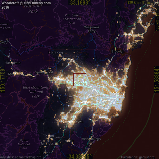
Analysis of Woodcroft night lights 2016
Square area 10x10 km:
 24.18%
90-99
33.15%80-89
26.01%70-79
13.19%60-69
2.93%50-59
0.55%40-49
0%30-39
0%20-29
0%10-19
0%0-9
0%Square area 50x50 km:
9.68%90-99
11.69%80-89
6.63%70-79
7.75%60-69
7.05%50-59
3.35%40-49
2.93%30-39
3.88%20-29
5.1%10-19
8.15%0-9
33.79%Clear (daylight) street map image can be seen on geolist.org.
Map coordinates:
33° 10' 11.3" South, 150° 10' 39.3" East
33° 45' 22.9" South, 150° 52' 50.6" East
34° 20' 20.2" South, 151° 35' 1.8" East
Some cities around Woodcroft sort by population:
• Blacktown
3.5 km =2.2 mi,  109°
109°
• Quakers Hill
2.6 km =1.6 mi,  5°
5°
• Rooty Hill
4.5 km =2.8 mi,  255°
255°
• Doonside
1.7 km =1.1 mi,  228°
228°
• Plumpton
4.1 km =2.5 mi,  277°
277°
• Marayong
1.4 km =0.9 mi,  50°
50°
• Oakhurst
4.4 km =2.7 mi,  296°
296°
• Glendenning
2.6 km =1.6 mi,  290°
290°
8349440 (p: 6,423)
Sources (retrieved 2019-11-25):
» Earth at Night: Flat Maps 2012, 2016