Plumpton night lights from space
Night Light of Plumpton (New South Wales) from space (Australia) Src. Average luminocity for 10x10km area is 83.8059% and for 50x50km: 39.389%.
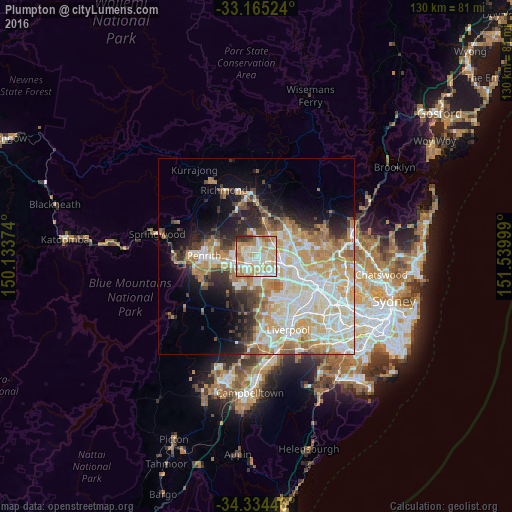
Analysis of Plumpton night lights 2016
Square area 10x10 km:
 18.86%
90-99
29.12%80-89
16.67%70-79
17.58%60-69
10.81%50-59
1.65%40-49
1.83%30-39
3.11%20-29
0.37%10-19
0%0-9
0%Square area 50x50 km:
8.56%90-99
10.28%80-89
5.68%70-79
6.73%60-69
6.2%50-59
3.01%40-49
2.84%30-39
3.63%20-29
4.82%10-19
7.8%0-9
40.47%Clear (daylight) street map image can be seen on geolist.org.
Map coordinates:
33° 9' 54.9" South, 150° 8' 1.5" East
33° 45' 6.6" South, 150° 50' 12.7" East
34° 20' 4.1" South, 151° 32' 24" East
Some cities around Plumpton sort by population:
• Mount Druitt
2.5 km =1.6 mi,  228°
228°
• Rooty Hill
1.7 km =1.1 mi,  191°
191°
• Doonside
3.2 km =2 mi,  120°
120°
• Oakhurst
1.5 km =0.9 mi,  5°
5°
• Whalan
3.1 km =1.9 mi,  259°
259°
• Hebersham
1.4 km =0.9 mi,  299°
299°
• Minchinbury
4 km =2.5 mi, 189°
• Glendenning
1.6 km =1 mi,  76°
76°
8347892 (p: 9,208)
Sources (retrieved 2019-11-25):
» Earth at Night: Flat Maps 2012, 2016