Marayong night lights from space
Night Light of Marayong (New South Wales) from space (Australia) Src. Average luminocity for 10x10km area is 89.3535% and for 50x50km: 44.5869%.
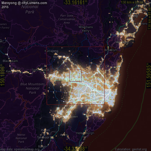
Analysis of Marayong night lights 2016
Square area 10x10 km:
 23.63%
90-99
32.05%80-89
24.73%70-79
15.02%60-69
3.48%50-59
1.1%40-49
0%30-39
0%20-29
0%10-19
0%0-9
0%Square area 50x50 km:
9.93%90-99
11.9%80-89
6.68%70-79
7.87%60-69
7.01%50-59
3.11%40-49
2.74%30-39
3.71%20-29
5.08%10-19
7.96%0-9
34.02%Clear (daylight) street map image can be seen on geolist.org.
Map coordinates:
33° 9' 41.8" South, 150° 11' 22.6" East
33° 44' 53.7" South, 150° 53' 33.8" East
34° 19' 51.2" South, 151° 35' 45.1" East
Some cities around Marayong sort by population:
• Blacktown
3 km =1.9 mi,  132°
132°
• Quakers Hill
1.9 km =1.2 mi,  332°
332°
• Glenwood
4.1 km =2.5 mi,  65°
65°
• Doonside
3.2 km =2 mi,  229°
229°
• Kings Langley
4 km =2.5 mi,  92°
92°
• Lalor Park
3.8 km =2.4 mi,  111°
111°
• Woodcroft
1.4 km =0.9 mi, 230°
• Glendenning
3.6 km =2.2 mi,  269°
269°
8348667 (p: 7,675)
Sources (retrieved 2019-11-25):
» Earth at Night: Flat Maps 2012, 2016