Oakhurst night lights from space
Night Light of Oakhurst (New South Wales) from space (Australia) Src. Average luminocity for 10x10km area is 79.8388% and for 50x50km: 38.2709%.
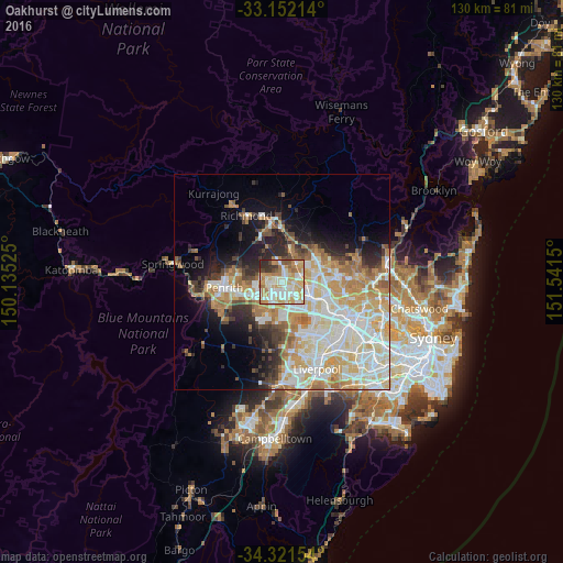
Analysis of Oakhurst night lights 2016
Square area 10x10 km:
 16.85%
90-99
26.19%80-89
16.67%70-79
14.47%60-69
11.72%50-59
4.03%40-49
2.75%30-39
4.03%20-29
3.3%10-19
0%0-9
0%Square area 50x50 km:
8.41%90-99
10.05%80-89
5.67%70-79
6.58%60-69
5.86%50-59
2.62%40-49
2.62%30-39
3.54%20-29
4.71%10-19
7.57%0-9
42.38%Clear (daylight) street map image can be seen on geolist.org.
Map coordinates:
33° 9' 7.7" South, 150° 8' 6.9" East
33° 44' 19.8" South, 150° 50' 18.1" East
34° 19' 17.5" South, 151° 32' 29.4" East
Some cities around Oakhurst sort by population:
• Quakers Hill
4.2 km =2.6 mi,  81°
81°
• Mount Druitt
3.7 km =2.3 mi,  212°
212°
• Rooty Hill
3.1 km =1.9 mi,  188°
188°
• Doonside
4.1 km =2.5 mi,  139°
139°
• Plumpton
1.5 km =0.9 mi, 185°
• Whalan
3.8 km =2.4 mi,  237°
237°
• Hebersham
1.6 km =1 mi, 239°
• Glendenning
1.8 km =1.1 mi,  125°
125°
8348163 (p: 6,978)
Sources (retrieved 2019-11-25):
» Earth at Night: Flat Maps 2012, 2016