Glendenning night lights from space
Night Light of Glendenning (New South Wales) from space (Australia) Src. Average luminocity for 10x10km area is 85.2656% and for 50x50km: 40.7151%.
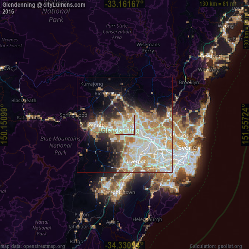
Analysis of Glendenning night lights 2016
Square area 10x10 km:
 20.51%
90-99
30.04%80-89
19.41%70-79
16.3%60-69
7.33%50-59
2.01%40-49
0.73%30-39
3.3%20-29
0.37%10-19
0%0-9
0%Square area 50x50 km:
8.92%90-99
10.7%80-89
6.07%70-79
7.02%60-69
6.32%50-59
2.95%40-49
2.76%30-39
3.64%20-29
4.86%10-19
7.81%0-9
38.96%Clear (daylight) street map image can be seen on geolist.org.
Map coordinates:
33° 9' 42" South, 150° 9' 3.6" East
33° 44' 53.9" South, 150° 51' 14.8" East
34° 19' 51.4" South, 151° 33' 26.1" East
Some cities around Glendenning sort by population:
• Quakers Hill
3.2 km =2 mi,  58°
58°
• Rooty Hill
2.8 km =1.7 mi,  223°
223°
• Doonside
2.3 km =1.4 mi,  150°
150°
• Plumpton
1.6 km =1 mi,  256°
256°
• Marayong
3.6 km =2.2 mi,  89°
89°
• Oakhurst
1.8 km =1.1 mi,  305°
305°
• Woodcroft
2.6 km =1.6 mi,  110°
110°
• Hebersham
2.8 km =1.7 mi,  275°
275°
8348565 (p: 5,131)
Sources (retrieved 2019-11-25):
» Earth at Night: Flat Maps 2012, 2016