Blacktown night lights from space
Night Light of Blacktown (New South Wales) from space (Australia) Src. Average luminocity for 10x10km area is 91.3901% and for 50x50km: 47.8636%.

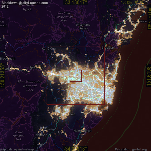
Analysis of Blacktown night lights 2016
Square area 10x10 km:
 28.21%
90-99
34.43%80-89
22.89%70-79
13.19%60-69
1.28%50-59
0%40-49
0%30-39
0%20-29
0%10-19
0%0-9
0%Square area 50x50 km:
10.91%90-99
12.39%80-89
6.81%70-79
8.4%60-69
7.92%50-59
3.66%40-49
3.1%30-39
4.24%20-29
5.43%10-19
7.99%0-9
29.17%Clear (daylight) street map image can be seen on geolist.org.
Map coordinates:
33° 10' 48.6" South, 150° 12' 48.8" East
33° 46' 0" South, 150° 55' 0" East
34° 20' 57" South, 151° 37' 11.3" East
Some cities around Blacktown sort by population:
• Seven Hills
2.4 km =1.5 mi,  140°
140°
• Glenwood
4 km =2.5 mi,  21°
21°
• Toongabbie
3.6 km =2.2 mi,  121°
121°
• Kings Langley
2.5 km =1.6 mi,  43°
43°
• Marayong
3 km =1.9 mi,  312°
312°
• Lalor Park
1.5 km =0.9 mi,  64°
64°
• Woodcroft
3.5 km =2.2 mi,  289°
289°
• Girraween
4.3 km =2.7 mi,  145°
145°
2175411 (p: 46,942)
Sources (retrieved 2019-11-25):
» Earth at Night: Flat Maps 2012, 2016