Alderley night lights from space
Night Light of Alderley (Queensland) from space (Australia) Src. Average luminocity for 10x10km area is 86.2311% and for 50x50km: 42.6934%.
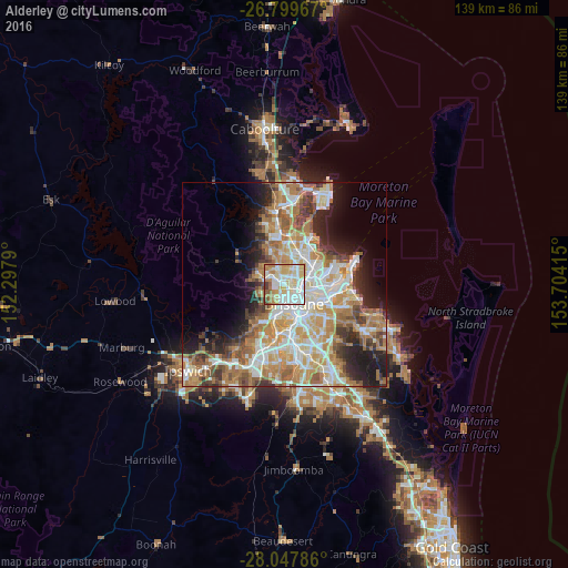
Analysis of Alderley night lights 2016
Square area 10x10 km:
 25.19%
90-99
26.14%80-89
21.78%70-79
7.95%60-69
12.12%50-59
3.22%40-49
3.03%30-39
0.57%20-29
0%10-19
0%0-9
0%Square area 50x50 km:
8.65%90-99
9.46%80-89
5.6%70-79
5.89%60-69
10.93%50-59
3.93%40-49
4.42%30-39
4.14%20-29
6.09%10-19
8.52%0-9
32.38%Clear (daylight) street map image can be seen on geolist.org.
Map coordinates:
26° 47' 58.8" South, 152° 17' 52.4" East
27° 25' 31.9" South, 153° 0' 3.7" East
28° 2' 52.3" South, 153° 42' 14.9" East
Some cities around Alderley sort by population:
• Ashgrove
2.4 km =1.5 mi,  201°
201°
• Everton Park
2.4 km =1.5 mi,  328°
328°
• Mitchelton
3.5 km =2.2 mi,  286°
286°
• Kelvin Grove
2.8 km =1.7 mi,  154°
154°
• Windsor
3 km =1.9 mi,  113°
113°
• Stafford
1.9 km =1.2 mi,  30°
30°
• Red Hill
3 km =1.9 mi,  178°
178°
• Enoggera
2.6 km =1.6 mi,  263°
263°
8348606 (p: 5,918)
Sources (retrieved 2019-11-25):
» Earth at Night: Flat Maps 2012, 2016