Red Hill night lights from space
Night Light of Red Hill (Queensland) from space (Australia) Src. Average luminocity for 10x10km area is 89.4306% and for 50x50km: 44.4644%.
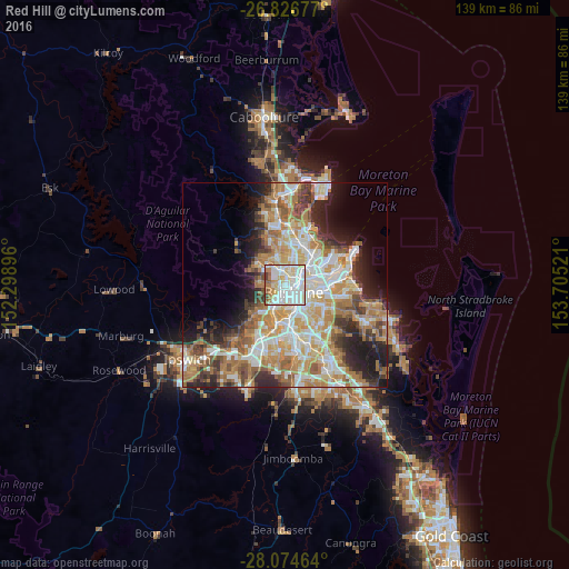
Analysis of Red Hill night lights 2016
Square area 10x10 km:
 32.94%
90-99
34.33%80-89
13.69%70-79
2.98%60-69
8.93%50-59
3.77%40-49
2.58%30-39
0.79%20-29
0%10-19
0%0-9
0%Square area 50x50 km:
8.98%90-99
9.64%80-89
5.72%70-79
6.22%60-69
11.61%50-59
4.06%40-49
4.74%30-39
4.44%20-29
6.93%10-19
8.32%0-9
29.35%Clear (daylight) street map image can be seen on geolist.org.
Map coordinates:
26° 49' 36.4" South, 152° 17' 56.3" East
27° 27' 8.9" South, 153° 0' 7.5" East
28° 4' 28.7" South, 153° 42' 18.8" East
Some cities around Red Hill sort by population:
• Ashgrove
1.3 km =0.8 mi,  307°
307°
• Bardon
2.4 km =1.5 mi,  247°
247°
• Paddington
1 km =0.6 mi,  221°
221°
• Kelvin Grove
1.2 km =0.7 mi,  66°
66°
• Fortitude Valley
3 km =1.9 mi,  99°
99°
• Spring Hill
2.3 km =1.4 mi,  115°
115°
• Auchenflower
2.6 km =1.6 mi,  201°
201°
• Alderley
3 km =1.9 mi,  358°
358°
8349259 (p: 5,390)
Sources (retrieved 2019-11-25):
» Earth at Night: Flat Maps 2012, 2016