Altona Meadows night lights from space
Night Light of Altona Meadows (Victoria) from space (Australia) Src. Average luminocity for 10x10km area is 62.3669% and for 50x50km: 35.8405%.
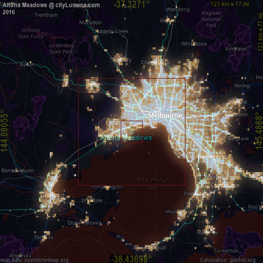
Analysis of Altona Meadows night lights 2016
Square area 10x10 km:
 17.69%
90-99
14.77%80-89
6.49%70-79
8.44%60-69
9.58%50-59
7.63%40-49
3.57%30-39
5.68%20-29
11.04%10-19
10.71%0-9
4.38%Square area 50x50 km:
11.64%90-99
9.43%80-89
4.64%70-79
4.79%60-69
3.23%50-59
2.36%40-49
1.86%30-39
2.09%20-29
4.07%10-19
7.2%0-9
48.68%Clear (daylight) street map image can be seen on geolist.org.
Map coordinates:
37° 19' 37.6" South, 144° 4' 50" East
37° 53' 2.9" South, 144° 47' 1.2" East
38° 26' 13.1" South, 145° 29' 12.5" East
Some cities around Altona Meadows sort by population:
• Point Cook
4.5 km =2.8 mi,  220°
220°
• Hoppers Crossing
7.3 km =4.5 mi,  271°
271°
• Truganina
8.1 km =5 mi,  338°
338°
• Newport
9.9 km =6.2 mi,  63°
63°
• Derrimut
10.3 km =6.4 mi,  353°
353°
• Williams Landing
4.3 km =2.7 mi,  305°
305°
• Seabrook
2.2 km =1.4 mi,  279°
279°
• Laverton
2.7 km =1.7 mi,  333°
333°
9972579 (p: 18,874)
Sources (retrieved 2019-11-25):
» Earth at Night: Flat Maps 2012, 2016