Whittlesea night lights from space
Night Light of Whittlesea (Victoria) from space (Australia) Src. Average luminocity for 10x10km area is 2.3977% and for 50x50km: 14.6124%.
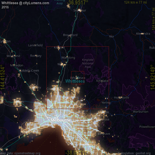
Analysis of Whittlesea night lights 2016
Square area 10x10 km:
 0%
0%90-99
0%80-89
0%70-79
0.49%60-69
0.16%50-59
0.65%40-49
0.65%30-39
0.32%20-29
0.32%10-19
1.3%0-9
96.1%Square area 50x50 km:
2.55%90-99
2.93%80-89
1.74%70-79
3.37%60-69
2.51%50-59
1.57%40-49
1.65%30-39
1.53%20-29
2.25%10-19
3.83%0-9
76.07%Clear (daylight) street map image can be seen on geolist.org.
Map coordinates:
36° 57' 6.1" South, 144° 24' 54.9" East
37° 30' 41.5" South, 145° 7' 6.1" East
38° 4' 1.8" South, 145° 49' 17.4" East
Some cities around Whittlesea sort by population:
• Epping
17.1 km =10.6 mi,  205°
205°
• Mill Park
17.8 km =11.1 mi,  194°
194°
• South Morang
15.5 km =9.6 mi, 185°
• Doreen
10.2 km =6.3 mi,  164°
164°
• Mernda
10.1 km =6.3 mi, 191°
• Diamond Creek
17.5 km =10.9 mi,  170°
170°
• Wallan
16.3 km =10.1 mi,  310°
310°
• Wollert
11 km =6.8 mi,  223°
223°
2143747 (p: 5,552)
Sources (retrieved 2019-11-25):
» Earth at Night: Flat Maps 2012, 2016