Wallan night lights from space
Night Light of Wallan (Victoria) from space (Australia) Src. Average luminocity for 10x10km area is 5.4951% and for 50x50km: 5.8885%.
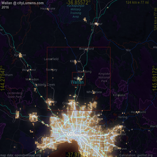
Analysis of Wallan night lights 2016
Square area 10x10 km:
 0%
0%90-99
0%80-89
0.65%70-79
2.11%60-69
2.44%50-59
0%40-49
0%30-39
1.62%20-29
1.62%10-19
0%0-9
91.56%Square area 50x50 km:
0.38%90-99
0.64%80-89
0.27%70-79
1.36%60-69
1.16%50-59
1.05%40-49
1.18%30-39
1.14%20-29
1.91%10-19
3.61%0-9
87.3%Clear (daylight) street map image can be seen on geolist.org.
Map coordinates:
36° 51' 20.6" South, 144° 16' 31.7" East
37° 24' 58.5" South, 144° 58' 42.9" East
37° 58' 21.4" South, 145° 40' 54.2" East
Some cities around Wallan sort by population:
• Craigieburn
20.6 km =12.8 mi,  187°
187°
• Roxburgh Park
23.8 km =14.8 mi, 191°
• Doreen
25.4 km =15.8 mi,  143°
143°
• Mernda
23 km =14.3 mi,  153°
153°
• Greenvale
26.1 km =16.2 mi,  202°
202°
• Wollert
19.2 km =11.9 mi,  165°
165°
• Kilmore
13.6 km =8.5 mi,  350°
350°
• Whittlesea
16.3 km =10.1 mi,  130°
130°
2144949 (p: 10,953)
Sources (retrieved 2019-11-25):
» Earth at Night: Flat Maps 2012, 2016