Epping night lights from space
Night Light of Epping (Victoria) from space (Australia) Src. Average luminocity for 10x10km area is 72.801% and for 50x50km: 41.0963%.

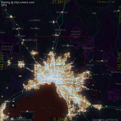
Analysis of Epping night lights 2016
Square area 10x10 km:
 13.61%
90-99
17.18%80-89
8.84%70-79
17.35%60-69
16.84%50-59
9.52%40-49
6.97%30-39
7.31%20-29
2.38%10-19
0%0-9
0%Square area 50x50 km:
11.83%90-99
10.12%80-89
5.34%70-79
6.68%60-69
5.79%50-59
3.59%40-49
3.11%30-39
2.32%20-29
3.46%10-19
5.46%0-9
42.31%Clear (daylight) street map image can be seen on geolist.org.
Map coordinates:
37° 5' 28.4" South, 144° 19' 48.8" East
37° 39' 0" South, 145° 1' 60" East
38° 12' 16.6" South, 145° 44' 11.3" East
Some cities around Epping sort by population:
• Mill Park
3.5 km =2.2 mi,  122°
122°
• Bundoora
5.8 km =3.6 mi,  156°
156°
• South Morang
5.9 km =3.7 mi,  90°
90°
• Lalor
2.4 km =1.5 mi,  218°
218°
• Thomastown
4 km =2.5 mi,  201°
201°
• Mernda
7.7 km =4.8 mi,  45°
45°
• Wollert
7.4 km =4.6 mi,  0°
0°
• Campbellfield
6.7 km =4.2 mi,  256°
256°
2167279 (p: 32,696)
Sources (retrieved 2019-11-25):
» Earth at Night: Flat Maps 2012, 2016