Whalan night lights from space
Night Light of Whalan (New South Wales) from space (Australia) Src. Average luminocity for 10x10km area is 78.859% and for 50x50km: 36.2155%.
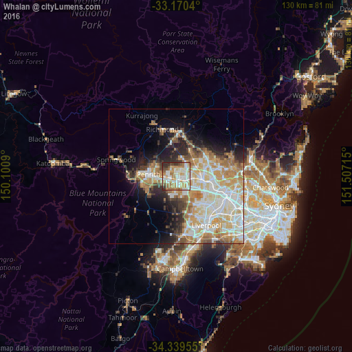
Analysis of Whalan night lights 2016
Square area 10x10 km:
 18.68%
90-99
25.46%80-89
9.34%70-79
15.93%60-69
14.47%50-59
4.58%40-49
4.03%30-39
5.13%20-29
2.38%10-19
0%0-9
0%Square area 50x50 km:
7.74%90-99
9.12%80-89
5%70-79
6.08%60-69
6.01%50-59
2.88%40-49
2.94%30-39
3.65%20-29
4.76%10-19
7.65%0-9
44.18%Clear (daylight) street map image can be seen on geolist.org.
Map coordinates:
33° 10' 13.4" South, 150° 6' 3.2" East
33° 45' 25.1" South, 150° 48' 14.5" East
34° 20' 22.4" South, 151° 30' 25.7" East
Some cities around Whalan sort by population:
• Mount Druitt
1.6 km =1 mi,  132°
132°
• Rooty Hill
2.9 km =1.8 mi,  111°
111°
• Plumpton
3.1 km =1.9 mi,  79°
79°
• Colyton
3 km =1.9 mi,  193°
193°
• Oakhurst
3.8 km =2.4 mi,  57°
57°
• Ropes Crossing
2.9 km =1.8 mi,  335°
335°
• Hebersham
2.2 km =1.4 mi, 55°
• Minchinbury
4.1 km =2.5 mi,  144°
144°
8347978 (p: 5,913)
Sources (retrieved 2019-11-25):
» Earth at Night: Flat Maps 2012, 2016