Colyton night lights from space
Night Light of Colyton (New South Wales) from space (Australia) Src. Average luminocity for 10x10km area is 78.1538% and for 50x50km: 37.0624%.
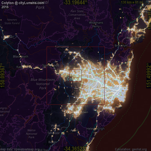
Analysis of Colyton night lights 2016
Square area 10x10 km:
 20.51%
90-99
22.89%80-89
6.59%70-79
17.4%60-69
16.12%50-59
5.86%40-49
1.1%30-39
4.21%20-29
5.13%10-19
0.18%0-9
0%Square area 50x50 km:
7.66%90-99
8.99%80-89
5.03%70-79
6.04%60-69
6.34%50-59
3.39%40-49
3.17%30-39
4.17%20-29
5.62%10-19
7.97%0-9
41.6%Clear (daylight) street map image can be seen on geolist.org.
Map coordinates:
33° 11' 47.2" South, 150° 5' 37.2" East
33° 46' 58.2" South, 150° 47' 48.4" East
34° 21' 54.8" South, 151° 29' 59.7" East
Some cities around Colyton sort by population:
• St Clair
2 km =1.2 mi,  214°
214°
• Mount Druitt
2.6 km =1.6 mi,  45°
45°
• Rooty Hill
3.8 km =2.4 mi,  61°
61°
• Plumpton
5.1 km =3.2 mi, 47°
• Erskine Park
3.4 km =2.1 mi,  178°
178°
• Whalan
3 km =1.9 mi,  13°
13°
• Hebersham
4.8 km =3 mi,  31°
31°
• Minchinbury
3.1 km =1.9 mi,  99°
99°
8348497 (p: 8,285)
Sources (retrieved 2019-11-25):
» Earth at Night: Flat Maps 2012, 2016