Minchinbury night lights from space
Night Light of Minchinbury (New South Wales) from space (Australia) Src. Average luminocity for 10x10km area is 85.493% and for 50x50km: 41.072%.
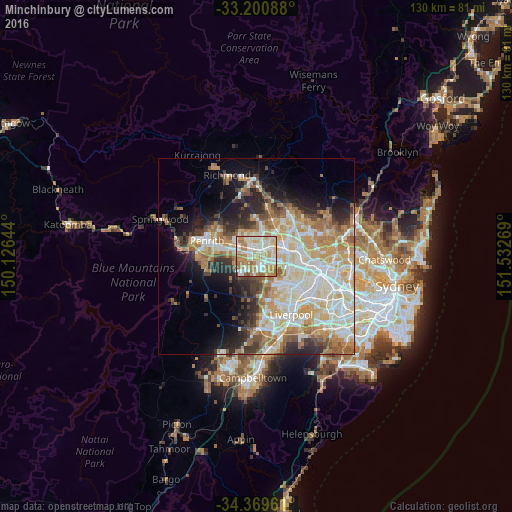
Analysis of Minchinbury night lights 2016
Square area 10x10 km:
 22.55%
90-99
27.97%80-89
12.06%70-79
18.88%60-69
15.03%50-59
2.62%40-49
0.87%30-39
0%20-29
0%10-19
0%0-9
0%Square area 50x50 km:
8.59%90-99
10.19%80-89
5.8%70-79
6.76%60-69
6.92%50-59
3.75%40-49
3.18%30-39
4.33%20-29
5.81%10-19
8.33%0-9
36.33%Clear (daylight) street map image can be seen on geolist.org.
Map coordinates:
33° 12' 3.2" South, 150° 7' 35.2" East
33° 47' 14.1" South, 150° 49' 46.4" East
34° 22' 10.6" South, 151° 31' 57.7" East
Some cities around Minchinbury sort by population:
• St Clair
4.3 km =2.7 mi,  254°
254°
• Mount Druitt
2.6 km =1.6 mi,  332°
332°
• Rooty Hill
2.3 km =1.4 mi,  8°
8°
• Doonside
4.1 km =2.5 mi,  56°
56°
• Plumpton
4 km =2.5 mi, 9°
• Colyton
3.1 km =1.9 mi,  279°
279°
• Erskine Park
4.1 km =2.5 mi,  225°
225°
• Whalan
4.1 km =2.5 mi,  324°
324°
8348687 (p: 5,627)
Sources (retrieved 2019-11-25):
» Earth at Night: Flat Maps 2012, 2016