Hebersham night lights from space
Night Light of Hebersham (New South Wales) from space (Australia) Src. Average luminocity for 10x10km area is 79.3205% and for 50x50km: 37.3733%.
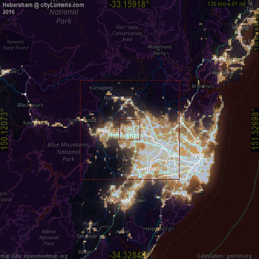
Analysis of Hebersham night lights 2016
Square area 10x10 km:
 18.13%
90-99
27.11%80-89
12.27%70-79
13.92%60-69
13.37%50-59
3.48%40-49
2.93%30-39
4.21%20-29
4.58%10-19
0%0-9
0%Square area 50x50 km:
8.23%90-99
9.66%80-89
5.46%70-79
6.34%60-69
5.84%50-59
2.61%40-49
2.66%30-39
3.54%20-29
4.74%10-19
7.56%0-9
43.36%Clear (daylight) street map image can be seen on geolist.org.
Map coordinates:
33° 9' 33" South, 150° 7' 14.6" East
33° 44' 45" South, 150° 49' 25.9" East
34° 19' 42.5" South, 151° 31' 37.1" East
Some cities around Hebersham sort by population:
• Mount Druitt
2.4 km =1.5 mi,  195°
195°
• Rooty Hill
2.5 km =1.6 mi,  159°
159°
• Doonside
4.6 km =2.9 mi,  120°
120°
• Plumpton
1.4 km =0.9 mi, 119°
• Oakhurst
1.6 km =1 mi,  59°
59°
• Ropes Crossing
3.4 km =2.1 mi,  295°
295°
• Whalan
2.2 km =1.4 mi,  235°
235°
• Glendenning
2.8 km =1.7 mi,  95°
95°
8348512 (p: 5,660)
Sources (retrieved 2019-11-25):
» Earth at Night: Flat Maps 2012, 2016