West Melbourne night lights from space
Night Light of West Melbourne (Victoria) from space (Australia) Src. Average luminocity for 10x10km area is 98.2126% and for 50x50km: 54.9165%.
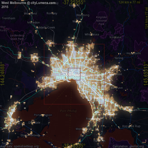
Analysis of West Melbourne night lights 2016
Square area 10x10 km:
 73.98%
90-99
21.43%80-89
2.55%70-79
0%60-69
0%50-59
2.04%40-49
0%30-39
0%20-29
0%10-19
0%0-9
0%Square area 50x50 km:
15.32%90-99
14.1%80-89
6.94%70-79
9.24%60-69
7.43%50-59
4.59%40-49
3.52%30-39
3.55%20-29
6.11%10-19
8.05%0-9
21.16%Clear (daylight) street map image can be seen on geolist.org.
Map coordinates:
37° 15' 9.2" South, 144° 14' 48.8" East
37° 48' 36.5" South, 144° 57' 0" East
38° 21' 48.8" South, 145° 39' 11.3" East
Some cities around West Melbourne sort by population:
• Melbourne
1.2 km =0.7 mi,  110°
110°
• Melbourne City Centre
1.6 km =1 mi, 110°
• Southbank
1.9 km =1.2 mi,  138°
138°
• Carlton
1.8 km =1.1 mi,  52°
52°
• North Melbourne
1.4 km =0.9 mi,  342°
342°
• Docklands
0.5 km =0.3 mi,  175°
175°
• Fitzroy
2.8 km =1.7 mi,  62°
62°
• Kensington
2.6 km =1.6 mi,  320°
320°
7281818 (p: 5,588)
Sources (retrieved 2019-11-25):
» Earth at Night: Flat Maps 2012, 2016