Docklands night lights from space
Night Light of Docklands (Victoria) from space (Australia) Src. Average luminocity for 10x10km area is 97.0272% and for 50x50km: 54.7895%.
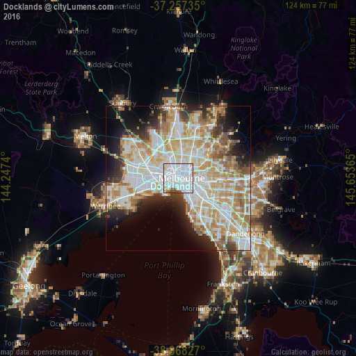
Analysis of Docklands night lights 2016
Square area 10x10 km:
 72.62%
90-99
20.58%80-89
2.38%70-79
0%60-69
0%50-59
3.06%40-49
1.36%30-39
0%20-29
0%10-19
0%0-9
0%Square area 50x50 km:
15.31%90-99
14.07%80-89
6.94%70-79
9.21%60-69
7.42%50-59
4.57%40-49
3.46%30-39
3.59%20-29
6.06%10-19
7.91%0-9
21.47%Clear (daylight) street map image can be seen on geolist.org.
Map coordinates:
37° 15' 26.5" South, 144° 14' 50.6" East
37° 48' 53.6" South, 144° 57' 1.9" East
38° 22' 5.8" South, 145° 39' 13.1" East
Some cities around Docklands sort by population:
• Melbourne
1.1 km =0.7 mi,  84°
84°
• Melbourne City Centre
1.4 km =0.9 mi,  90°
90°
• Southbank
1.5 km =0.9 mi,  125°
125°
• Carlton
2.2 km =1.4 mi,  40°
40°
• Port Melbourne
2.8 km =1.7 mi,  194°
194°
• North Melbourne
1.9 km =1.2 mi,  345°
345°
• South Melbourne
2.5 km =1.6 mi,  145°
145°
• West Melbourne
0.5 km =0.3 mi,  355°
355°
7521471 (p: 12,486)
Sources (retrieved 2019-11-25):
» Earth at Night: Flat Maps 2012, 2016