Fitzroy night lights from space
Night Light of Fitzroy (Victoria) from space (Australia) Src. Average luminocity for 10x10km area is 97.9337% and for 50x50km: 56.055%.
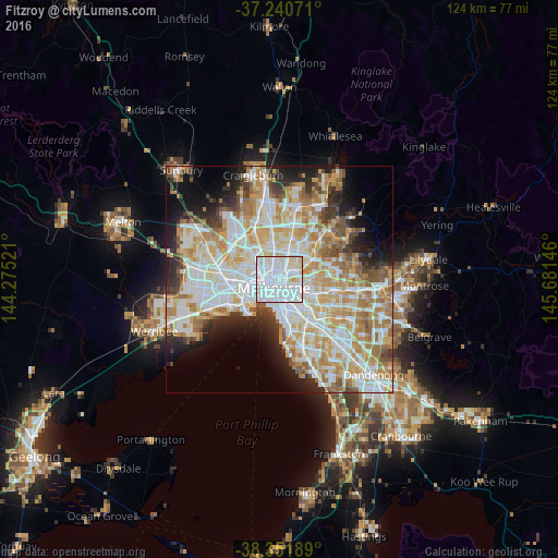
Analysis of Fitzroy night lights 2016
Square area 10x10 km:
 67.52%
90-99
22.28%80-89
9.35%70-79
0.85%60-69
0%50-59
0%40-49
0%30-39
0%20-29
0%10-19
0%0-9
0%Square area 50x50 km:
15.43%90-99
14.23%80-89
7.12%70-79
9.64%60-69
8.07%50-59
4.83%40-49
3.7%30-39
3.45%20-29
5.86%10-19
7.91%0-9
19.75%Clear (daylight) street map image can be seen on geolist.org.
Map coordinates:
37° 14' 26.6" South, 144° 16' 30.8" East
37° 47' 54.2" South, 144° 58' 42" East
38° 21' 6.8" South, 145° 40' 53.3" East
Some cities around Fitzroy sort by population:
• Melbourne
2.2 km =1.4 mi,  217°
217°
• Melbourne City Centre
2.1 km =1.3 mi,  209°
209°
• Carlton
1 km =0.6 mi,  260°
260°
• Collingwood
1 km =0.6 mi,  116°
116°
• Abbotsford
1.9 km =1.2 mi,  95°
95°
• East Melbourne
2.2 km =1.4 mi,  157°
157°
• Carlton North
1.3 km =0.8 mi,  327°
327°
• Clifton Hill
1.5 km =0.9 mi,  88°
88°
2166584 (p: 11,267)
Sources (retrieved 2019-11-25):
» Earth at Night: Flat Maps 2012, 2016