Carlton night lights from space
Night Light of Carlton (Victoria) from space (Australia) Src. Average luminocity for 10x10km area is 98.5017% and for 50x50km: 55.7319%.
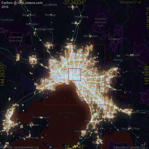
Analysis of Carlton night lights 2016
Square area 10x10 km:
 71.43%
90-99
22.11%80-89
5.61%70-79
0.85%60-69
0%50-59
0%40-49
0%30-39
0%20-29
0%10-19
0%0-9
0%Square area 50x50 km:
15.41%90-99
14.21%80-89
7.04%70-79
9.52%60-69
7.71%50-59
4.82%40-49
3.65%30-39
3.45%20-29
5.99%10-19
8.41%0-9
19.79%Clear (daylight) street map image can be seen on geolist.org.
Map coordinates:
37° 14' 32.4" South, 144° 15' 48.8" East
37° 48' 0" South, 144° 58' 0" East
38° 21' 12.5" South, 145° 40' 11.3" East
Some cities around Carlton sort by population:
• Melbourne
1.6 km =1 mi,  190°
190°
• Melbourne City Centre
1.7 km =1.1 mi,  180°
180°
• North Melbourne
1.9 km =1.2 mi,  276°
276°
• Docklands
2.2 km =1.4 mi,  220°
220°
• Fitzroy North
1.7 km =1.1 mi,  40°
40°
• Fitzroy
1 km =0.6 mi,  80°
80°
• Collingwood
2 km =1.2 mi,  98°
98°
• West Melbourne
1.8 km =1.1 mi,  232°
232°
2172293 (p: 18,829)
Sources (retrieved 2019-11-25):
» Earth at Night: Flat Maps 2012, 2016