North Melbourne night lights from space
Night Light of North Melbourne (Victoria) from space (Australia) Src. Average luminocity for 10x10km area is 98.9796% and for 50x50km: 54.9402%.
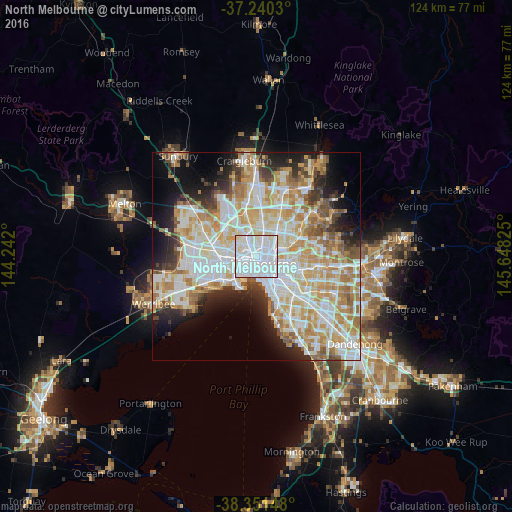
Analysis of North Melbourne night lights 2016
Square area 10x10 km:
 73.13%
90-99
23.64%80-89
3.23%70-79
0%60-69
0%50-59
0%40-49
0%30-39
0%20-29
0%10-19
0%0-9
0%Square area 50x50 km:
15.18%90-99
14.02%80-89
6.96%70-79
9.3%60-69
7.47%50-59
4.61%40-49
3.63%30-39
3.41%20-29
6.19%10-19
8.72%0-9
20.51%Clear (daylight) street map image can be seen on geolist.org.
Map coordinates:
37° 14' 25.1" South, 144° 14' 31.2" East
37° 47' 52.7" South, 144° 56' 42.4" East
38° 21' 5.3" South, 145° 38' 53.7" East
Some cities around North Melbourne sort by population:
• Melbourne
2.4 km =1.5 mi,  138°
138°
• Carlton
1.9 km =1.2 mi,  96°
96°
• Docklands
1.9 km =1.2 mi,  165°
165°
• Kensington
1.4 km =0.9 mi,  298°
298°
• Parkville
1.7 km =1.1 mi,  14°
14°
• Flemington
1.7 km =1.1 mi,  309°
309°
• Carlton North
2.5 km =1.6 mi,  63°
63°
• West Melbourne
1.4 km =0.9 mi,  162°
162°
2154912 (p: 15,395)
Sources (retrieved 2019-11-25):
» Earth at Night: Flat Maps 2012, 2016