Wanneroo night lights from space
Night Light of Wanneroo (Western Australia) from space (Australia) Src. Average luminocity for 10x10km area is 65.8297% and for 50x50km: 27.3674%.
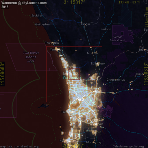
Analysis of Wanneroo night lights 2016
Square area 10x10 km:
 14.65%
90-99
12.82%80-89
6.41%70-79
11.36%60-69
17.03%50-59
10.99%40-49
6.23%30-39
5.49%20-29
8.79%10-19
5.86%0-9
0.37%Square area 50x50 km:
6.43%90-99
6.7%80-89
2.35%70-79
3.65%60-69
5.15%50-59
2.87%40-49
1.95%30-39
2.96%20-29
5.02%10-19
7.66%0-9
55.24%Clear (daylight) street map image can be seen on geolist.org.
Map coordinates:
31° 9' 0.6" South, 115° 5' 48.8" East
31° 45' 0" South, 115° 48' 0" East
32° 20' 45.5" South, 116° 30' 11.3" East
Some cities around Wanneroo sort by population:
• Joondalup
3.1 km =1.9 mi,  281°
281°
• Tapping
3.4 km =2.1 mi,  352°
352°
• Banksia Grove
6 km =3.7 mi,  4°
4°
• Woodvale
4.4 km =2.7 mi,  184°
184°
• Currambine
5.3 km =3.3 mi,  290°
290°
• Heathridge
4.1 km =2.5 mi,  250°
250°
• Hocking
2.8 km =1.7 mi,  142°
142°
• Craigie
5 km =3.1 mi,  214°
214°
2059124 (p: 11,721)
Sources (retrieved 2019-11-25):
» Earth at Night: Flat Maps 2012, 2016