Joondalup night lights from space
Night Light of Joondalup (Western Australia) from space (Australia) Src. Average luminocity for 10x10km area is 72.8553% and for 50x50km: 26.0958%.
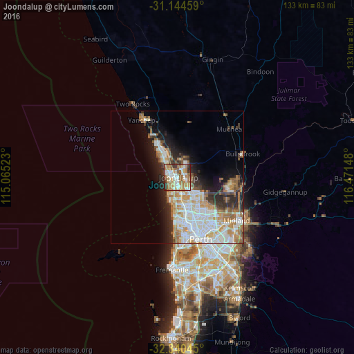
Analysis of Joondalup night lights 2016
Square area 10x10 km:
 15.57%
90-99
16.48%80-89
8.42%70-79
13.37%60-69
20.33%50-59
10.07%40-49
4.21%30-39
5.68%20-29
5.86%10-19
0%0-9
0%Square area 50x50 km:
6.25%90-99
6.56%80-89
2.33%70-79
3.54%60-69
4.74%50-59
2.59%40-49
1.67%30-39
2.67%20-29
4.73%10-19
7.02%0-9
57.9%Clear (daylight) street map image can be seen on geolist.org.
Map coordinates:
31° 8' 40.5" South, 115° 3' 54.8" East
31° 44' 40" South, 115° 46' 6.1" East
32° 20' 25.6" South, 116° 28' 17.3" East
Some cities around Joondalup sort by population:
• Wanneroo
3.1 km =1.9 mi,  101°
101°
• Tapping
3.8 km =2.4 mi,  42°
42°
• Ocean Reef
3.4 km =2.1 mi,  242°
242°
• Currambine
2.3 km =1.4 mi,  302°
302°
• Kinross
4 km =2.5 mi,  315°
315°
• Heathridge
2.2 km =1.4 mi,  203°
203°
• Craigie
4.8 km =3 mi,  178°
178°
• Iluka
3.7 km =2.3 mi,  285°
285°
6695255 (p: 9,302)
Sources (retrieved 2019-11-25):
» Earth at Night: Flat Maps 2012, 2016