Vaucluse night lights from space
Night Light of Vaucluse (New South Wales) from space (Australia) Src. Average luminocity for 10x10km area is 46.5874% and for 50x50km: 33.2809%.
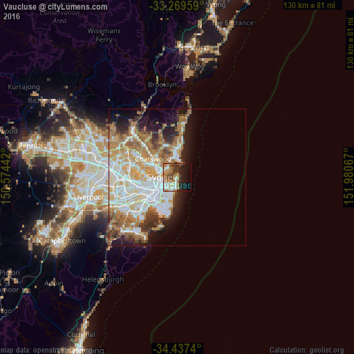
Analysis of Vaucluse night lights 2016
Square area 10x10 km:
 6.99%
6.99%90-99
10.66%80-89
2.62%70-79
8.39%60-69
11.19%50-59
5.59%40-49
5.77%30-39
7.17%20-29
9.62%10-19
17.83%0-9
14.16%Square area 50x50 km:
7.66%90-99
8.13%80-89
3.89%70-79
5.11%60-69
7.01%50-59
3.25%40-49
2.01%30-39
3.21%20-29
3.95%10-19
7.15%0-9
48.63%Clear (daylight) street map image can be seen on geolist.org.
Map coordinates:
33° 16' 10.5" South, 150° 34' 27.9" East
33° 51' 19.8" South, 151° 16' 39.1" East
34° 26' 14.6" South, 151° 58' 50.4" East
Some cities around Vaucluse sort by population:
• Mosman
4 km =2.5 mi,  297°
297°
• Potts Point
4.9 km =3 mi,  254°
254°
• Bondi Beach
3.9 km =2.4 mi,  178°
178°
• Bellevue Hill
3.6 km =2.2 mi,  223°
223°
• Rose Bay
1.6 km =1 mi,  203°
203°
• Bondi
4.5 km =2.8 mi, 195°
• Bondi Junction
5 km =3.1 mi,  214°
214°
• North Bondi
3.6 km =2.2 mi, 175°
2145299 (p: 9,205)
Sources (retrieved 2019-11-25):
» Earth at Night: Flat Maps 2012, 2016