Potts Point night lights from space
Night Light of Potts Point (New South Wales) from space (Australia) Src. Average luminocity for 10x10km area is 84.5087% and for 50x50km: 39.5006%.
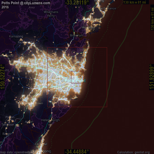
Analysis of Potts Point night lights 2016
Square area 10x10 km:
 35.49%
90-99
23.25%80-89
4.72%70-79
13.81%60-69
9.62%50-59
3.85%40-49
4.9%30-39
4.02%20-29
0.35%10-19
0%0-9
0%Square area 50x50 km:
9.16%90-99
9.8%80-89
4.81%70-79
6.45%60-69
7.69%50-59
3.6%40-49
2.42%30-39
3.54%20-29
4.77%10-19
8.58%0-9
39.19%Clear (daylight) street map image can be seen on geolist.org.
Map coordinates:
33° 16' 52.3" South, 150° 31' 21.9" East
33° 52' 1.2" South, 151° 13' 33.1" East
34° 26' 55.8" South, 151° 55' 44.4" East
Some cities around Potts Point sort by population:
• Sydney
1.7 km =1.1 mi,  266°
266°
• Sydney Central Business District
1.7 km =1.1 mi,  278°
278°
• Surry Hills
2.2 km =1.4 mi,  212°
212°
• Paddington
2 km =1.2 mi,  164°
164°
• Darlinghurst
1.5 km =0.9 mi,  203°
203°
• Haymarket
2.3 km =1.4 mi,  235°
235°
• Woollahra
2.5 km =1.6 mi, 156°
• Elizabeth Bay
0.5 km =0.3 mi,  168°
168°
2152625 (p: 12,168)
Sources (retrieved 2019-11-25):
» Earth at Night: Flat Maps 2012, 2016