Bellevue Hill night lights from space
Night Light of Bellevue Hill (New South Wales) from space (Australia) Src. Average luminocity for 10x10km area is 72.1941% and for 50x50km: 36.5162%.
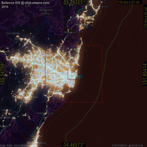
Analysis of Bellevue Hill night lights 2016
Square area 10x10 km:
 25.17%
90-99
21.68%80-89
3.67%70-79
10.31%60-69
8.39%50-59
4.72%40-49
4.37%30-39
4.72%20-29
9.97%10-19
6.99%0-9
0%Square area 50x50 km:
8.56%90-99
8.92%80-89
4.37%70-79
5.75%60-69
7.37%50-59
3.45%40-49
2.35%30-39
3.27%20-29
4.35%10-19
7.84%0-9
43.76%Clear (daylight) street map image can be seen on geolist.org.
Map coordinates:
33° 17' 35.7" South, 150° 32' 52.4" East
33° 52' 44.4" South, 151° 15' 3.6" East
34° 27' 38.6" South, 151° 57' 14.9" East
Some cities around Bellevue Hill sort by population:
• Paddington
1.9 km =1.2 mi,  252°
252°
• Potts Point
2.7 km =1.7 mi,  299°
299°
• Rose Bay
2.1 km =1.3 mi,  57°
57°
• Bondi
2.1 km =1.3 mi,  143°
143°
• Bondi Junction
1.6 km =1 mi,  192°
192°
• North Bondi
2.9 km =1.8 mi,  109°
109°
• Woollahra
1.6 km =1 mi,  233°
233°
• Elizabeth Bay
2.4 km =1.5 mi,  289°
289°
2207748 (p: 10,599)
Sources (retrieved 2019-11-25):
» Earth at Night: Flat Maps 2012, 2016