North Bondi night lights from space
Night Light of North Bondi (New South Wales) from space (Australia) Src. Average luminocity for 10x10km area is 45.3741% and for 50x50km: 32.2694%.
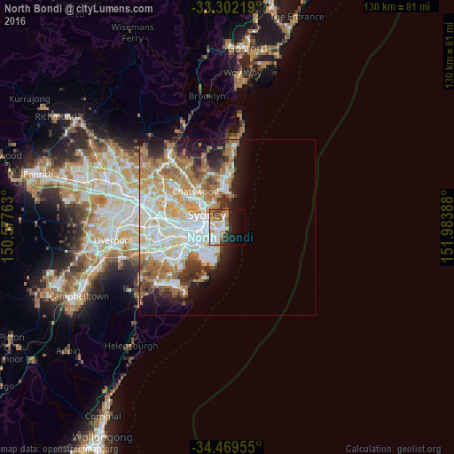
Analysis of North Bondi night lights 2016
Square area 10x10 km:
 9.97%
9.97%90-99
13.11%80-89
2.8%70-79
7.34%60-69
5.24%50-59
4.37%40-49
5.07%30-39
3.15%20-29
10.49%10-19
16.96%0-9
21.5%Square area 50x50 km:
7.6%90-99
7.98%80-89
3.8%70-79
4.93%60-69
6.62%50-59
3.2%40-49
1.97%30-39
2.82%20-29
3.77%10-19
6.68%0-9
50.63%Clear (daylight) street map image can be seen on geolist.org.
Map coordinates:
33° 18' 7.9" South, 150° 34' 39.5" East
33° 53' 16.3" South, 151° 16' 50.7" East
34° 28' 10.4" South, 151° 59' 2" East
Some cities around North Bondi sort by population:
• Bondi Beach
0.4 km =0.2 mi,  212°
212°
• Bellevue Hill
2.9 km =1.8 mi,  289°
289°
• Rose Bay
2.3 km =1.4 mi,  336°
336°
• Bondi
1.7 km =1.1 mi,  244°
244°
• Bondi Junction
3.1 km =1.9 mi,  260°
260°
• Vaucluse
3.6 km =2.2 mi,  355°
355°
• Woollahra
4.1 km =2.5 mi,  270°
270°
• Bronte
2.1 km =1.3 mi,  221°
221°
9972847 (p: 8,926)
Sources (retrieved 2019-11-25):
» Earth at Night: Flat Maps 2012, 2016