The Ponds night lights from space
Night Light of The Ponds (New South Wales) from space (Australia) Src. Average luminocity for 10x10km area is 70.9103% and for 50x50km: 39.9016%.
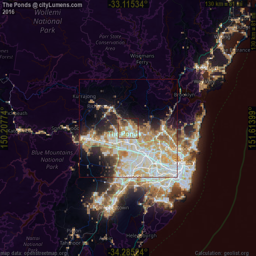
Analysis of The Ponds night lights 2016
Square area 10x10 km:
 12.27%
90-99
13.74%80-89
14.1%70-79
16.85%60-69
16.48%50-59
8.42%40-49
6.04%30-39
4.21%20-29
6.41%10-19
1.47%0-9
0%Square area 50x50 km:
9.05%90-99
10.28%80-89
5.83%70-79
7.28%60-69
6.44%50-59
2.61%40-49
2.43%30-39
3.41%20-29
4.83%10-19
7.26%0-9
40.58%Clear (daylight) street map image can be seen on geolist.org.
Map coordinates:
33° 6' 55.2" South, 150° 12' 27.9" East
33° 42' 8.2" South, 150° 54' 39.1" East
34° 17' 6.9" South, 151° 36' 50.4" East
Some cities around The Ponds sort by population:
• Kellyville
3.8 km =2.4 mi,  103°
103°
• Quakers Hill
4.3 km =2.7 mi,  216°
216°
• Glenwood
4 km =2.5 mi,  149°
149°
• Kellyville Ridge
0.7 km =0.4 mi,  82°
82°
• Stanhope Gardens
2.6 km =1.6 mi, 147°
• Beaumont Hills
2.8 km =1.7 mi, 84°
• Rouse Hill
2.3 km =1.4 mi,  10°
10°
• Riverstone
4.6 km =2.9 mi,  297°
297°
8349329 (p: 11,642)
Sources (retrieved 2019-11-25):
» Earth at Night: Flat Maps 2012, 2016