Glenwood night lights from space
Night Light of Glenwood (New South Wales) from space (Australia) Src. Average luminocity for 10x10km area is 84.7747% and for 50x50km: 45.3496%.
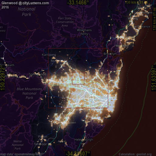
Analysis of Glenwood night lights 2016
Square area 10x10 km:
 19.23%
90-99
24.54%80-89
21.79%70-79
21.79%60-69
7.69%50-59
2.2%40-49
2.38%30-39
0.37%20-29
0%10-19
0%0-9
0%Square area 50x50 km:
11.02%90-99
11.92%80-89
6.73%70-79
7.95%60-69
6.94%50-59
2.77%40-49
2.63%30-39
3.68%20-29
4.94%10-19
7.23%0-9
34.18%Clear (daylight) street map image can be seen on geolist.org.
Map coordinates:
33° 8' 47.8" South, 150° 13' 47" East
33° 43' 60" South, 150° 55' 58.2" East
34° 18' 57.9" South, 151° 38' 9.5" East
Some cities around Glenwood sort by population:
• Blacktown
4 km =2.5 mi,  201°
201°
• Kellyville
3.1 km =1.9 mi,  33°
33°
• Kellyville Ridge
3.8 km =2.4 mi,  338°
338°
• Kings Langley
1.9 km =1.2 mi,  172°
172°
• Stanhope Gardens
1.4 km =0.9 mi,  333°
333°
• Beaumont Hills
3.8 km =2.4 mi,  11°
11°
• Bella Vista
2.2 km =1.4 mi,  113°
113°
• Lalor Park
3.1 km =1.9 mi,  182°
182°
8348142 (p: 16,040)
Sources (retrieved 2019-11-25):
» Earth at Night: Flat Maps 2012, 2016