Rouse Hill night lights from space
Night Light of Rouse Hill (New South Wales) from space (Australia) Src. Average luminocity for 10x10km area is 54.0916% and for 50x50km: 37.3482%.
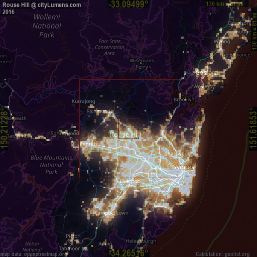
Analysis of Rouse Hill night lights 2016
Square area 10x10 km:
 5.86%
5.86%90-99
8.42%80-89
8.97%70-79
10.07%60-69
17.4%50-59
8.24%40-49
6.23%30-39
5.49%20-29
10.81%10-19
15.57%0-9
2.93%Square area 50x50 km:
8.25%90-99
9.32%80-89
5.18%70-79
6.97%60-69
6.5%50-59
2.65%40-49
2.4%30-39
3.33%20-29
4.71%10-19
7.12%0-9
43.58%Clear (daylight) street map image can be seen on geolist.org.
Map coordinates:
33° 5' 42" South, 150° 12' 44.2" East
33° 40' 55.5" South, 150° 54' 55.4" East
34° 15' 54.6" South, 151° 37' 6.7" East
Some cities around Rouse Hill sort by population:
• Kellyville
4.5 km =2.8 mi,  133°
133°
• Quakers Hill
6.4 km =4 mi,  207°
207°
• Glenwood
5.9 km =3.7 mi,  164°
164°
• The Ponds
2.3 km =1.4 mi,  190°
190°
• Kellyville Ridge
2.2 km =1.4 mi,  173°
173°
• Stanhope Gardens
4.6 km =2.9 mi, 167°
• Beaumont Hills
3.1 km =1.9 mi, 129°
• Riverstone
4.5 km =2.8 mi,  268°
268°
7281823 (p: 7,877)
Sources (retrieved 2019-11-25):
» Earth at Night: Flat Maps 2012, 2016