Riverstone night lights from space
Night Light of Riverstone (New South Wales) from space (Australia) Src. Average luminocity for 10x10km area is 51.8278% and for 50x50km: 34.3104%.
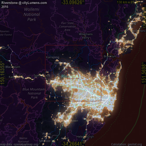
Analysis of Riverstone night lights 2016
Square area 10x10 km:
 5.49%
5.49%90-99
6.78%80-89
5.68%70-79
6.59%60-69
16.85%50-59
10.44%40-49
9.89%30-39
10.07%20-29
18.32%10-19
9.89%0-9
0%Square area 50x50 km:
7.34%90-99
8.59%80-89
4.81%70-79
6.14%60-69
5.73%50-59
2.54%40-49
2.43%30-39
3.31%20-29
4.59%10-19
7.31%0-9
47.22%Clear (daylight) street map image can be seen on geolist.org.
Map coordinates:
33° 5' 46.5" South, 150° 9' 48.8" East
33° 40' 60" South, 150° 52' 0" East
34° 15' 59.1" South, 151° 34' 11.3" East
Some cities around Riverstone sort by population:
• Quakers Hill
5.8 km =3.6 mi,  164°
164°
• The Ponds
4.6 km =2.9 mi,  117°
117°
• Kellyville Ridge
5.2 km =3.2 mi,  113°
113°
• Stanhope Gardens
7 km =4.3 mi,  128°
128°
• Beaumont Hills
7.1 km =4.4 mi, 105°
• Rouse Hill
4.5 km =2.8 mi,  88°
88°
• Oakhurst
6.7 km =4.2 mi,  202°
202°
• Glendenning
7.3 km =4.5 mi,  189°
189°
2151522 (p: 7,191)
Sources (retrieved 2019-11-25):
» Earth at Night: Flat Maps 2012, 2016