Beaumont Hills night lights from space
Night Light of Beaumont Hills (New South Wales) from space (Australia) Src. Average luminocity for 10x10km area is 64.0769% and for 50x50km: 40.8997%.
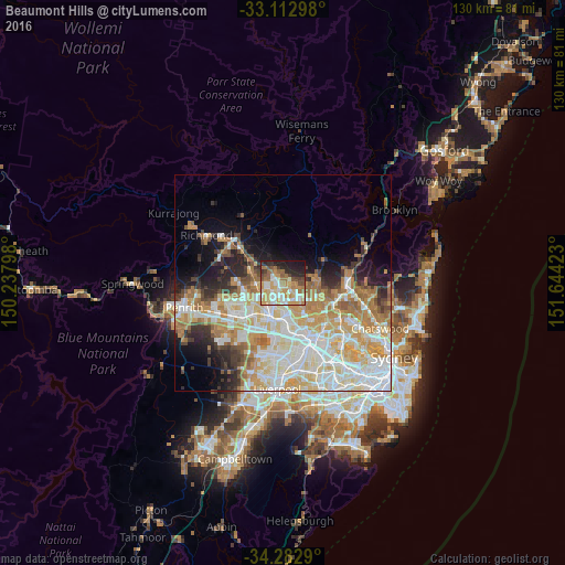
Analysis of Beaumont Hills night lights 2016
Square area 10x10 km:
 11.17%
90-99
13%80-89
10.81%70-79
14.29%60-69
13.92%50-59
6.23%40-49
6.78%30-39
3.66%20-29
11.9%10-19
8.24%0-9
0%Square area 50x50 km:
9.63%90-99
10.45%80-89
5.91%70-79
7.3%60-69
6.73%50-59
2.7%40-49
2.51%30-39
3.38%20-29
4.74%10-19
6.88%0-9
39.77%Clear (daylight) street map image can be seen on geolist.org.
Map coordinates:
33° 6' 46.7" South, 150° 14' 16.7" East
33° 41' 59.7" South, 150° 56' 28" East
34° 16' 58.4" South, 151° 38' 39.2" East
Some cities around Beaumont Hills sort by population:
• Kellyville
1.5 km =0.9 mi,  141°
141°
• Glenwood
3.8 km =2.4 mi,  191°
191°
• The Ponds
2.8 km =1.7 mi,  264°
264°
• Kellyville Ridge
2.2 km =1.4 mi,  265°
265°
• Stanhope Gardens
2.8 km =1.7 mi,  209°
209°
• Bella Vista
4.8 km =3 mi,  164°
164°
• Rouse Hill
3.1 km =1.9 mi,  309°
309°
• Glenhaven
5.4 km =3.4 mi,  90°
90°
8436118 (p: 8,944)
Sources (retrieved 2019-11-25):
» Earth at Night: Flat Maps 2012, 2016