Tamborine Mountain night lights from space
Night Light of Tamborine Mountain (Queensland) from space (Australia) Src. Average luminocity for 10x10km area is 0.5303% and for 50x50km: 15.4828%.
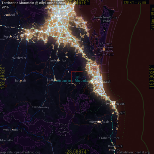
Analysis of Tamborine Mountain night lights 2016
Square area 10x10 km:
 0%
0%90-99
0%80-89
0%70-79
0%60-69
0%50-59
0%40-49
0%30-39
0.76%20-29
0%10-19
0%0-9
99.24%Square area 50x50 km:
2.61%90-99
2.76%80-89
1.35%70-79
1.18%60-69
4.78%50-59
1.79%40-49
1.9%30-39
2.18%20-29
3.22%10-19
7.73%0-9
70.51%Clear (daylight) street map image can be seen on geolist.org.
Map coordinates:
27° 20' 48.3" South, 152° 29' 46.5" East
27° 58' 10.3" South, 153° 11' 57.7" East
28° 35' 19.5" South, 153° 54' 9" East
Some cities around Tamborine Mountain sort by population:
• Upper Coomera
13.4 km =8.3 mi,  39°
39°
• Helensvale
14.3 km =8.9 mi,  66°
66°
• Nerang
13.6 km =8.5 mi,  99°
99°
• Pacific Pines
11.8 km =7.3 mi, 73°
• Oxenford
14.2 km =8.8 mi,  51°
51°
• Highland Park
14 km =8.7 mi,  110°
110°
• Molendinar
15.8 km =9.8 mi,  91°
91°
• Maudsland
7 km =4.3 mi, 71°
6951440 (p: 7,675)
Sources (retrieved 2019-11-25):
» Earth at Night: Flat Maps 2012, 2016