Highland Park night lights from space
Night Light of Highland Park (Queensland) from space (Australia) Src. Average luminocity for 10x10km area is 49.9811% and for 50x50km: 16.3195%.
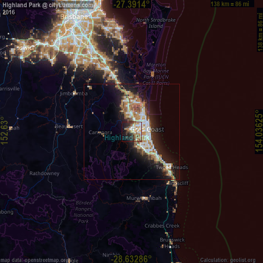
Analysis of Highland Park night lights 2016
Square area 10x10 km:
 8.33%
8.33%90-99
10.04%80-89
3.79%70-79
6.63%60-69
14.58%50-59
6.63%40-49
4.55%30-39
9.28%20-29
12.5%10-19
14.39%0-9
9.28%Square area 50x50 km:
2.82%90-99
2.98%80-89
1.52%70-79
1.24%60-69
4.64%50-59
1.69%40-49
1.93%30-39
1.97%20-29
3.99%10-19
9.84%0-9
67.37%Clear (daylight) street map image can be seen on geolist.org.
Map coordinates:
27° 23' 29" South, 152° 37' 48" East
28° 0' 50.1" South, 153° 19' 59.2" East
28° 37' 58.3" South, 154° 2' 10.5" East
Some cities around Highland Park sort by population:
• Nerang
2.7 km =1.7 mi,  6°
6°
• Carrara
3.4 km =2.1 mi,  104°
104°
• Ashmore
5.1 km =3.2 mi,  56°
56°
• Benowa
5.2 km =3.2 mi,  82°
82°
• Parkwood
7.2 km =4.5 mi,  24°
24°
• Merrimac
5.7 km =3.5 mi,  136°
136°
• Molendinar
5.2 km =3.2 mi,  31°
31°
• Worongary
4.3 km =2.7 mi,  157°
157°
8348148 (p: 6,436)
Sources (retrieved 2019-11-25):
» Earth at Night: Flat Maps 2012, 2016