Nerang night lights from space
Night Light of Nerang (Queensland) from space (Australia) Src. Average luminocity for 10x10km area is 60.6307% and for 50x50km: 16.6536%.
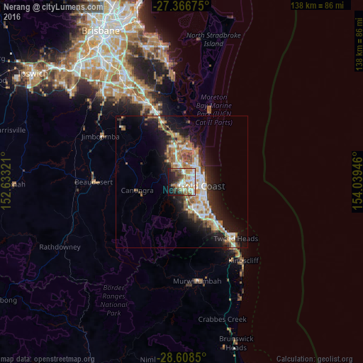
Analysis of Nerang night lights 2016
Square area 10x10 km:
 11.17%
90-99
16.48%80-89
4.17%70-79
8.71%60-69
15.15%50-59
7.77%40-49
5.11%30-39
8.52%20-29
10.8%10-19
10.23%0-9
1.89%Square area 50x50 km:
2.85%90-99
2.98%80-89
1.54%70-79
1.24%60-69
4.76%50-59
1.79%40-49
1.9%30-39
2.09%20-29
4.19%10-19
10.09%0-9
66.57%Clear (daylight) street map image can be seen on geolist.org.
Map coordinates:
27° 22' 0.3" South, 152° 37' 59.6" East
27° 59' 21.9" South, 153° 20' 10.8" East
28° 36' 30.6" South, 154° 2' 22.1" East
Some cities around Nerang sort by population:
• Pacific Pines
5.9 km =3.7 mi,  338°
338°
• Carrara
4.6 km =2.9 mi,  140°
140°
• Ashmore
3.9 km =2.4 mi,  89°
89°
• Arundel
6.3 km =3.9 mi,  24°
24°
• Benowa
5.3 km =3.3 mi,  112°
112°
• Parkwood
4.7 km =2.9 mi,  34°
34°
• Highland Park
2.7 km =1.7 mi,  186°
186°
• Molendinar
2.9 km =1.8 mi,  54°
54°
2155542 (p: 16,739)
Sources (retrieved 2019-11-25):
» Earth at Night: Flat Maps 2012, 2016