South Windsor night lights from space
Night Light of South Windsor (New South Wales) from space (Australia) Src. Average luminocity for 10x10km area is 29.7875% and for 50x50km: 22.8751%.
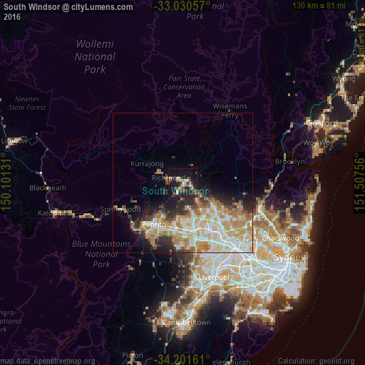
Analysis of South Windsor night lights 2016
Square area 10x10 km:
 3.3%
3.3%90-99
3.66%80-89
0.18%70-79
4.03%60-69
5.13%50-59
3.66%40-49
8.79%30-39
6.04%20-29
10.07%10-19
34.43%0-9
20.7%Square area 50x50 km:
4.28%90-99
4.95%80-89
3.05%70-79
4.29%60-69
4.53%50-59
1.88%40-49
2.19%30-39
2.44%20-29
3.64%10-19
6.33%0-9
62.42%Clear (daylight) street map image can be seen on geolist.org.
Map coordinates:
33° 1' 50.1" South, 150° 6' 4.7" East
33° 37' 5.1" South, 150° 48' 15.9" East
34° 12' 5.8" South, 151° 30' 27.2" East
Some cities around South Windsor sort by population:
• Cranebrook
13.2 km =8.2 mi,  221°
221°
• The Ponds
13.6 km =8.5 mi,  133°
133°
• Rouse Hill
12.5 km =7.8 mi,  124°
124°
• Riverstone
9.3 km =5.8 mi,  141°
141°
• Bligh Park
2.4 km =1.5 mi,  184°
184°
• Ropes Crossing
12.8 km =8 mi,  185°
185°
• Richmond
5.3 km =3.3 mi,  292°
292°
• Jordan Springs
13.5 km =8.4 mi,  211°
211°
9972943 (p: 5,855)
Sources (retrieved 2019-11-25):
» Earth at Night: Flat Maps 2012, 2016