Bligh Park night lights from space
Night Light of Bligh Park (New South Wales) from space (Australia) Src. Average luminocity for 10x10km area is 34.1245% and for 50x50km: 25.4352%.
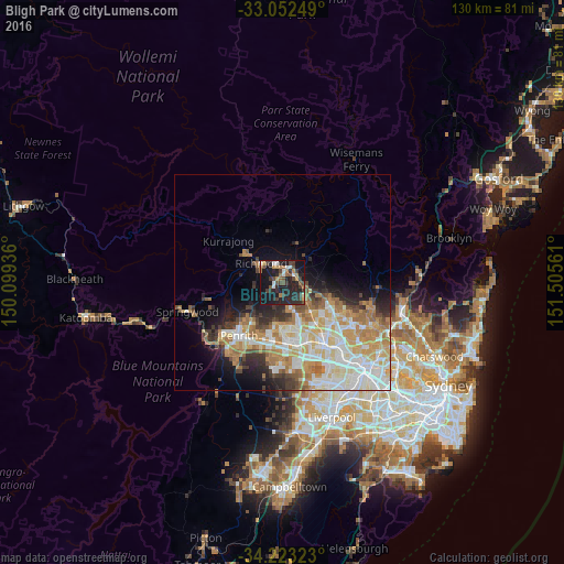
Analysis of Bligh Park night lights 2016
Square area 10x10 km:
 3.3%
3.3%90-99
3.66%80-89
0.73%70-79
4.21%60-69
5.86%50-59
3.66%40-49
9.16%30-39
9.52%20-29
21.98%10-19
34.25%0-9
3.66%Square area 50x50 km:
5.34%90-99
5.87%80-89
3.16%70-79
4.36%60-69
4.64%50-59
2.01%40-49
2.3%30-39
2.74%20-29
3.92%10-19
6.63%0-9
59.03%Clear (daylight) street map image can be seen on geolist.org.
Map coordinates:
33° 3' 9" South, 150° 5' 57.7" East
33° 38' 23.5" South, 150° 48' 8.9" East
34° 13' 23.6" South, 151° 30' 20.2" East
Some cities around Bligh Park sort by population:
• Cranebrook
11.3 km =7 mi,  229°
229°
• Rouse Hill
11.5 km =7.1 mi,  114°
114°
• Riverstone
7.7 km =4.8 mi,  129°
129°
• Oakhurst
11.5 km =7.1 mi,  163°
163°
• Ropes Crossing
10.4 km =6.5 mi,  185°
185°
• South Windsor
2.4 km =1.5 mi,  4°
4°
• Richmond
6.5 km =4 mi,  313°
313°
• Jordan Springs
11.3 km =7 mi,  216°
216°
8348531 (p: 6,322)
Sources (retrieved 2019-11-25):
» Earth at Night: Flat Maps 2012, 2016