Smithfield night lights from space
Night Light of Smithfield (New South Wales) from space (Australia) Src. Average luminocity for 10x10km area is 92.8794% and for 50x50km: 56.3726%.
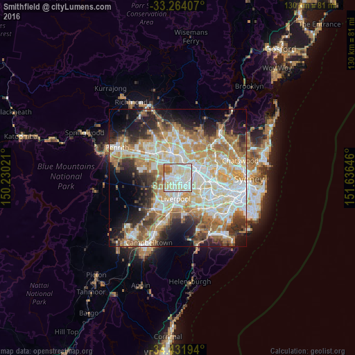
Analysis of Smithfield night lights 2016
Square area 10x10 km:
 35.31%
90-99
36.89%80-89
16.96%70-79
5.24%60-69
3.5%50-59
2.1%40-49
0%30-39
0%20-29
0%10-19
0%0-9
0%Square area 50x50 km:
12.71%90-99
13.66%80-89
7.58%70-79
9.23%60-69
10.26%50-59
5.54%40-49
4.05%30-39
5.88%20-29
7.57%10-19
9.81%0-9
13.7%Clear (daylight) street map image can be seen on geolist.org.
Map coordinates:
33° 15' 50.7" South, 150° 13' 48.8" East
33° 51' 0" South, 150° 55' 60" East
34° 25' 55" South, 151° 38' 11.3" East
Some cities around Smithfield sort by population:
• Greystanes
3.2 km =2 mi,  21°
21°
• Fairfield
2.4 km =1.5 mi,  140°
140°
• Fairfield West
2.4 km =1.5 mi,  219°
219°
• Canley Heights
3.7 km =2.3 mi,  193°
193°
• Fairfield Heights
1.7 km =1.1 mi,  162°
162°
• Merrylands West
3.8 km =2.4 mi,  59°
59°
• Wetherill Park
3.1 km =1.9 mi,  284°
284°
• Fairfield East
4.1 km =2.5 mi,  121°
121°
2149271 (p: 11,899)
Sources (retrieved 2019-11-25):
» Earth at Night: Flat Maps 2012, 2016