Canley Heights night lights from space
Night Light of Canley Heights (New South Wales) from space (Australia) Src. Average luminocity for 10x10km area is 92.1573% and for 50x50km: 56.0752%.
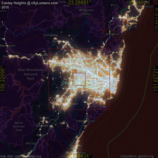
Analysis of Canley Heights night lights 2016
Square area 10x10 km:
 30.94%
90-99
36.36%80-89
15.56%70-79
15.91%60-69
1.22%50-59
0%40-49
0%30-39
0%20-29
0%10-19
0%0-9
0%Square area 50x50 km:
12.34%90-99
13.53%80-89
7.63%70-79
9.4%60-69
10.42%50-59
5.53%40-49
3.97%30-39
5.78%20-29
7.46%10-19
10.06%0-9
13.9%Clear (daylight) street map image can be seen on geolist.org.
Map coordinates:
33° 17' 48.9" South, 150° 13' 15.5" East
33° 52' 57.4" South, 150° 55' 26.7" East
34° 27' 51.6" South, 151° 37' 38" East
Some cities around Canley Heights sort by population:
• Cabramatta
1.9 km =1.2 mi,  149°
149°
• Fairfield
3 km =1.9 mi,  53°
53°
• Fairfield West
1.9 km =1.2 mi,  339°
339°
• Mount Pritchard
2.9 km =1.8 mi,  218°
218°
• Fairfield Heights
2.4 km =1.5 mi,  33°
33°
• Cabramatta West
1.6 km =1 mi, 224°
• St Johns Park
2.1 km =1.3 mi,  268°
268°
• Greenfield Park
3.1 km =1.9 mi,  286°
286°
8348469 (p: 10,936)
Sources (retrieved 2019-11-25):
» Earth at Night: Flat Maps 2012, 2016