Merrylands West night lights from space
Night Light of Merrylands West (New South Wales) from space (Australia) Src. Average luminocity for 10x10km area is 95.778% and for 50x50km: 57.9566%.
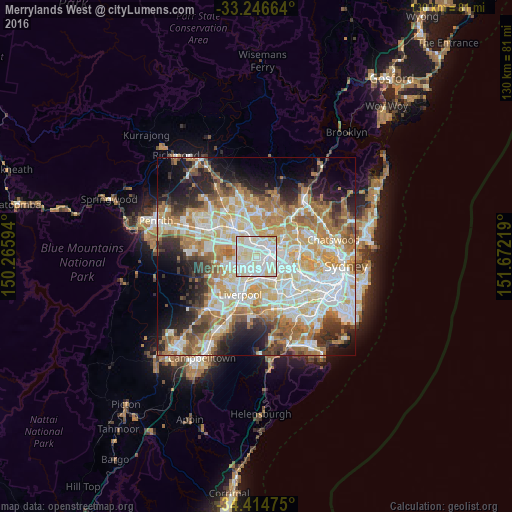
Analysis of Merrylands West night lights 2016
Square area 10x10 km:
 39.86%
90-99
41.96%80-89
16.43%70-79
1.75%60-69
0%50-59
0%40-49
0%30-39
0%20-29
0%10-19
0%0-9
0%Square area 50x50 km:
13.45%90-99
14.35%80-89
7.76%70-79
9.37%60-69
10.52%50-59
5.58%40-49
4%30-39
5.74%20-29
7.34%10-19
9%0-9
12.91%Clear (daylight) street map image can be seen on geolist.org.
Map coordinates:
33° 14' 47.9" South, 150° 15' 57.4" East
33° 49' 57.7" South, 150° 58' 8.6" East
34° 24' 53.1" South, 151° 40' 19.9" East
Some cities around Merrylands West sort by population:
• Parramatta
3.6 km =2.2 mi,  62°
62°
• Granville
3.7 km =2.3 mi,  103°
103°
• Greystanes
2.4 km =1.5 mi,  295°
295°
• Westmead
3.6 km =2.2 mi,  28°
28°
• Wentworthville
2.9 km =1.8 mi,  357°
357°
• Pendle Hill
3.4 km =2.1 mi,  338°
338°
• South Wentworthville
1.7 km =1.1 mi, 341°
• Harris Park
3.7 km =2.3 mi,  73°
73°
9972823 (p: 6,536)
Sources (retrieved 2019-11-25):
» Earth at Night: Flat Maps 2012, 2016