Fairfield West night lights from space
Night Light of Fairfield West (New South Wales) from space (Australia) Src. Average luminocity for 10x10km area is 89.243% and for 50x50km: 55.472%.
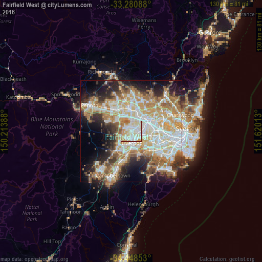
Analysis of Fairfield West night lights 2016
Square area 10x10 km:
 28.5%
28.5%90-99
31.29%80-89
15.73%70-79
14.51%60-69
7.87%50-59
2.1%40-49
0%30-39
0%20-29
0%10-19
0%0-9
0%Square area 50x50 km:
12.04%90-99
13.46%80-89
7.54%70-79
9.25%60-69
10.21%50-59
5.54%40-49
3.96%30-39
5.76%20-29
7.49%10-19
10.58%0-9
14.15%Clear (daylight) street map image can be seen on geolist.org.
Map coordinates:
33° 16' 51.2" South, 150° 12' 50" East
33° 52' 0.1" South, 150° 55' 1.2" East
34° 26' 54.7" South, 151° 37' 12.5" East
Some cities around Fairfield West sort by population:
• Bossley Park
3.1 km =1.9 mi,  280°
280°
• Smithfield
2.4 km =1.5 mi,  39°
39°
• Canley Heights
1.9 km =1.2 mi,  159°
159°
• Canley Vale
3.6 km =2.2 mi,  127°
127°
• Cabramatta West
3 km =1.9 mi,  189°
189°
• St Johns Park
2.3 km =1.4 mi,  217°
217°
• Wetherill Park
3.1 km =1.9 mi,  330°
330°
• Greenfield Park
2.5 km =1.6 mi,  249°
249°
6949378 (p: 11,456)
Sources (retrieved 2019-11-25):
» Earth at Night: Flat Maps 2012, 2016