Fairfield East night lights from space
Night Light of Fairfield East (New South Wales) from space (Australia) Src. Average luminocity for 10x10km area is 94.1259% and for 50x50km: 59.1624%.
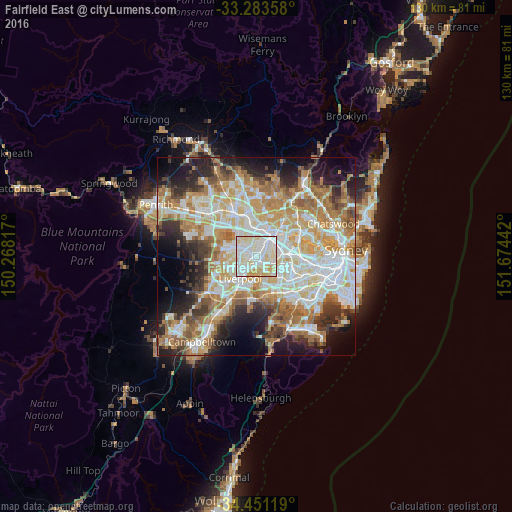
Analysis of Fairfield East night lights 2016
Square area 10x10 km:
 33.92%
90-99
38.81%80-89
20.28%70-79
6.99%60-69
0%50-59
0%40-49
0%30-39
0%20-29
0%10-19
0%0-9
0%Square area 50x50 km:
13.61%90-99
14.52%80-89
7.86%70-79
9.48%60-69
10.94%50-59
5.93%40-49
4.04%30-39
5.87%20-29
7.72%10-19
9.94%0-9
10.09%Clear (daylight) street map image can be seen on geolist.org.
Map coordinates:
33° 17' 0.9" South, 150° 16' 5.4" East
33° 52' 9.8" South, 150° 58' 16.6" East
34° 27' 4.3" South, 151° 40' 27.9" East
Some cities around Fairfield East sort by population:
• Merrylands
4.2 km =2.6 mi,  15°
15°
• Chester Hill
2.8 km =1.7 mi,  112°
112°
• Smithfield
4.1 km =2.5 mi,  301°
301°
• Canley Vale
2.9 km =1.8 mi,  228°
228°
• Bass Hill
3.9 km =2.4 mi,  145°
145°
• Merrylands West
4.1 km =2.5 mi,  357°
357°
• Villawood
1.9 km =1.2 mi, 153°
• South Granville
3.8 km =2.4 mi,  71°
71°
9972671 (p: 5,241)
Sources (retrieved 2019-11-25):
» Earth at Night: Flat Maps 2012, 2016