Shailer Park night lights from space
Night Light of Shailer Park (Queensland) from space (Australia) Src. Average luminocity for 10x10km area is 53.3016% and for 50x50km: 34.7579%.
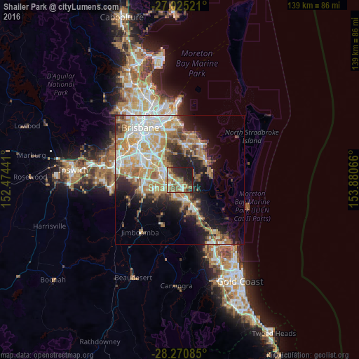
Analysis of Shailer Park night lights 2016
Square area 10x10 km:
 9.13%
9.13%90-99
6.94%80-89
5.16%70-79
4.56%60-69
20.83%50-59
8.53%40-49
5.56%30-39
5.95%20-29
18.85%10-19
14.48%0-9
0%Square area 50x50 km:
6.27%90-99
7.06%80-89
4.07%70-79
5.2%60-69
9.67%50-59
2.73%40-49
3.22%30-39
3.85%20-29
6.39%10-19
11.04%0-9
40.51%Clear (daylight) street map image can be seen on geolist.org.
Map coordinates:
27° 1' 30.8" South, 152° 28' 27.9" East
27° 38' 59.3" South, 153° 10' 39.1" East
28° 16' 15.1" South, 153° 52' 50.4" East
Some cities around Shailer Park sort by population:
• Eagleby
5.4 km =3.4 mi,  134°
134°
• Slacks Creek
2.7 km =1.7 mi,  269°
269°
• Loganlea
5.1 km =3.2 mi,  236°
236°
• Cornubia
4.3 km =2.7 mi,  115°
115°
• Mount Cotton
5.8 km =3.6 mi,  71°
71°
• Daisy Hill
2.9 km =1.8 mi,  318°
318°
• Loganholme
3.9 km =2.4 mi,  167°
167°
• Edens Landing
5.9 km =3.7 mi,  187°
187°
8347715 (p: 11,517)
Sources (retrieved 2019-11-25):
» Earth at Night: Flat Maps 2012, 2016