Mount Cotton night lights from space
Night Light of Mount Cotton (Queensland) from space (Australia) Src. Average luminocity for 10x10km area is 27.8651% and for 50x50km: 31.4071%.
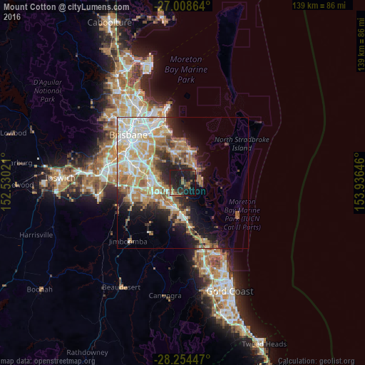
Analysis of Mount Cotton night lights 2016
Square area 10x10 km:
 0.6%
0.6%90-99
0.4%80-89
1.19%70-79
0%60-69
13.1%50-59
2.78%40-49
2.18%30-39
8.73%20-29
18.65%10-19
49.01%0-9
3.37%Square area 50x50 km:
5.92%90-99
6.57%80-89
3.91%70-79
4.6%60-69
8.17%50-59
2.34%40-49
2.72%30-39
3.29%20-29
5.62%10-19
10.22%0-9
46.64%Clear (daylight) street map image can be seen on geolist.org.
Map coordinates:
27° 0' 31.1" South, 152° 31' 48.8" East
27° 37' 60" South, 153° 13' 60" East
28° 15' 16.1" South, 153° 56' 11.3" East
Some cities around Mount Cotton sort by population:
• Redland Bay
7 km =4.3 mi,  69°
69°
• Thornlands
9 km =5.6 mi,  20°
20°
• Eagleby
5.8 km =3.6 mi,  196°
196°
• Shailer Park
5.8 km =3.6 mi,  251°
251°
• Slacks Creek
8.4 km =5.2 mi,  257°
257°
• Cornubia
4.1 km =2.5 mi, 203°
• Daisy Hill
7.4 km =4.6 mi,  272°
272°
• Loganholme
7.3 km =4.5 mi,  219°
219°
2156683 (p: 6,729)
Sources (retrieved 2019-11-25):
» Earth at Night: Flat Maps 2012, 2016