Daisy Hill night lights from space
Night Light of Daisy Hill (Queensland) from space (Australia) Src. Average luminocity for 10x10km area is 58.7044% and for 50x50km: 37.5395%.
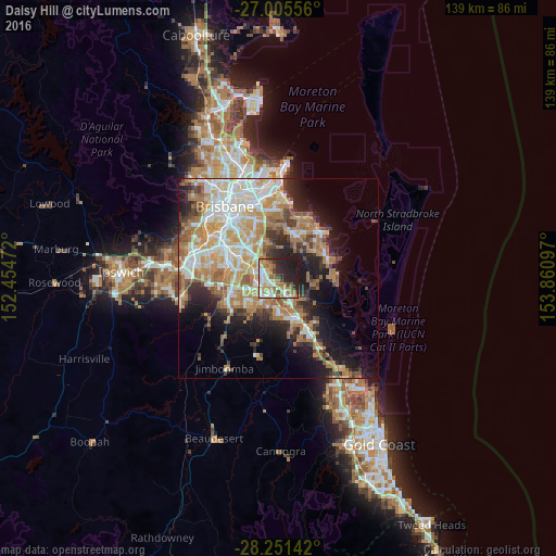
Analysis of Daisy Hill night lights 2016
Square area 10x10 km:
 13.69%
90-99
10.52%80-89
6.94%70-79
6.15%60-69
18.06%50-59
4.76%40-49
4.17%30-39
4.37%20-29
19.25%10-19
12.1%0-9
0%Square area 50x50 km:
7.09%90-99
7.81%80-89
4.44%70-79
5.43%60-69
10.12%50-59
3.05%40-49
3.46%30-39
4.05%20-29
6.63%10-19
11.37%0-9
36.55%Clear (daylight) street map image can be seen on geolist.org.
Map coordinates:
27° 0' 20" South, 152° 27' 17" East
27° 37' 48.9" South, 153° 9' 28.2" East
28° 15' 5.1" South, 153° 51' 39.5" East
Some cities around Daisy Hill sort by population:
• Logan City
4.9 km =3 mi,  258°
258°
• Rochedale South
5.2 km =3.2 mi,  318°
318°
• Shailer Park
2.9 km =1.8 mi,  138°
138°
• Slacks Creek
2.3 km =1.4 mi,  199°
199°
• Springwood
3.5 km =2.2 mi,  305°
305°
• Loganlea
5.5 km =3.4 mi, 204°
• Underwood
5.2 km =3.2 mi,  297°
297°
• Logan Central
5.2 km =3.2 mi,  253°
253°
8347882 (p: 6,558)
Sources (retrieved 2019-11-25):
» Earth at Night: Flat Maps 2012, 2016