Salisbury Downs night lights from space
Night Light of Salisbury Downs (South Australia) from space (Australia) Src. Average luminocity for 10x10km area is 81.456% and for 50x50km: 24.1601%.
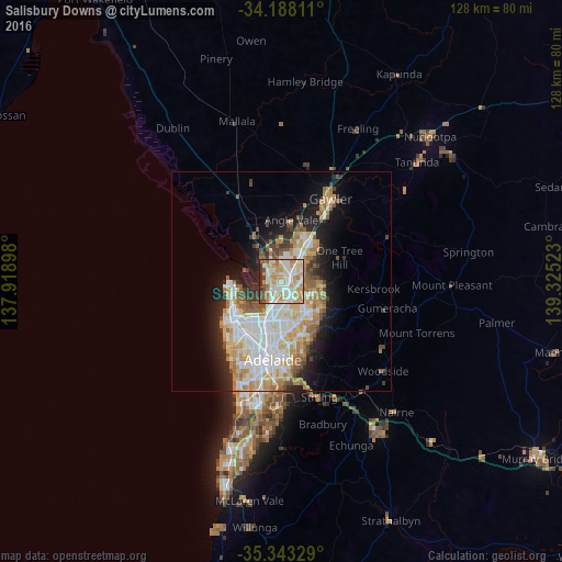
Analysis of Salisbury Downs night lights 2016
Square area 10x10 km:
 19.41%
90-99
26.01%80-89
15.02%70-79
20.15%60-69
6.04%50-59
3.85%40-49
3.66%30-39
4.76%20-29
1.1%10-19
0%0-9
0%Square area 50x50 km:
5.49%90-99
5.69%80-89
2.69%70-79
4.47%60-69
3.23%50-59
2.52%40-49
1.81%30-39
1.9%20-29
4%10-19
7.78%0-9
60.41%Clear (daylight) street map image can be seen on geolist.org.
Map coordinates:
34° 11' 17.2" South, 137° 55' 8.3" East
34° 46' 3.8" South, 138° 37' 19.6" East
35° 20' 35.8" South, 139° 19' 30.8" East
Some cities around Salisbury Downs sort by population:
• Parafield Gardens
1.9 km =1.2 mi,  212°
212°
• Paralowie
1.7 km =1.1 mi,  313°
313°
• Mawson Lakes
5.5 km =3.4 mi,  193°
193°
• Wynn Vale
6.9 km =4.3 mi,  120°
120°
• Pooraka
6.3 km =3.9 mi,  176°
176°
• Modbury Heights
7.4 km =4.6 mi,  128°
128°
• Para Hills
5.9 km =3.7 mi,  146°
146°
• Burton
4.2 km =2.6 mi,  334°
334°
9973264 (p: 5,933)
Sources (retrieved 2019-11-25):
» Earth at Night: Flat Maps 2012, 2016